Three Types of Geography Data
Our Politics & Advocacy clients will see three types of Geography data in their Resonate accounts:
- Region and State from our research data (self-reported survey responses)
- DMA® data derived from address-based modeling aligned to voter file geography
- State, DMA® and Congressional District from our address and IP-based Geography data
1. Region and State
Region and State data continue to come from our U.S. Consumer Study, where respondents identify where they live. These attributes live in the Resonate Elements taxonomy under Demographics → Demographics → Geography and are weighted to represent the U.S. online adult population. Use these when you need representative, projected counts of people living in a given region or state.
2. DMA®
DMA® data leverages address-based modeling informed by voter file geography. This data is appended to our survey respondents to enable state- and market-level insights. Because this data comes from external geographic sources and not from survey responses, projected counts may vary slightly from other population benchmarks.
3. State, DMA® and Congressional District
The Geography data type includes State, DMA®, and Congressional District attributes that use IP and address-based geographic data to assign audiences accurately to political and media boundaries. You’ll find these in the Additional Data taxonomy under Geography. When viewing insights, you can explore these boundaries to better understand where audiences are represented.
When to use Which Data Type
Use Region and State (Resonate Elements) when:
- You want to build an audience based on where people live and vote.
- You want to see projected audience sizes aligned to the U.S. online adult population.
Use DMA® and Congressional District (Additional Data → Geography) when:
- You want granular insights to understand where your audience is represented.
- You want to identify geographic areas for budget focus or targeting strategy.
- You want activation-ready counts for specific DMAs® or districts.
Use Voter-file-aligned DMA® data when:
- You need counts based on registered voters by DMA® and want to analyze political reach with that specific lens.
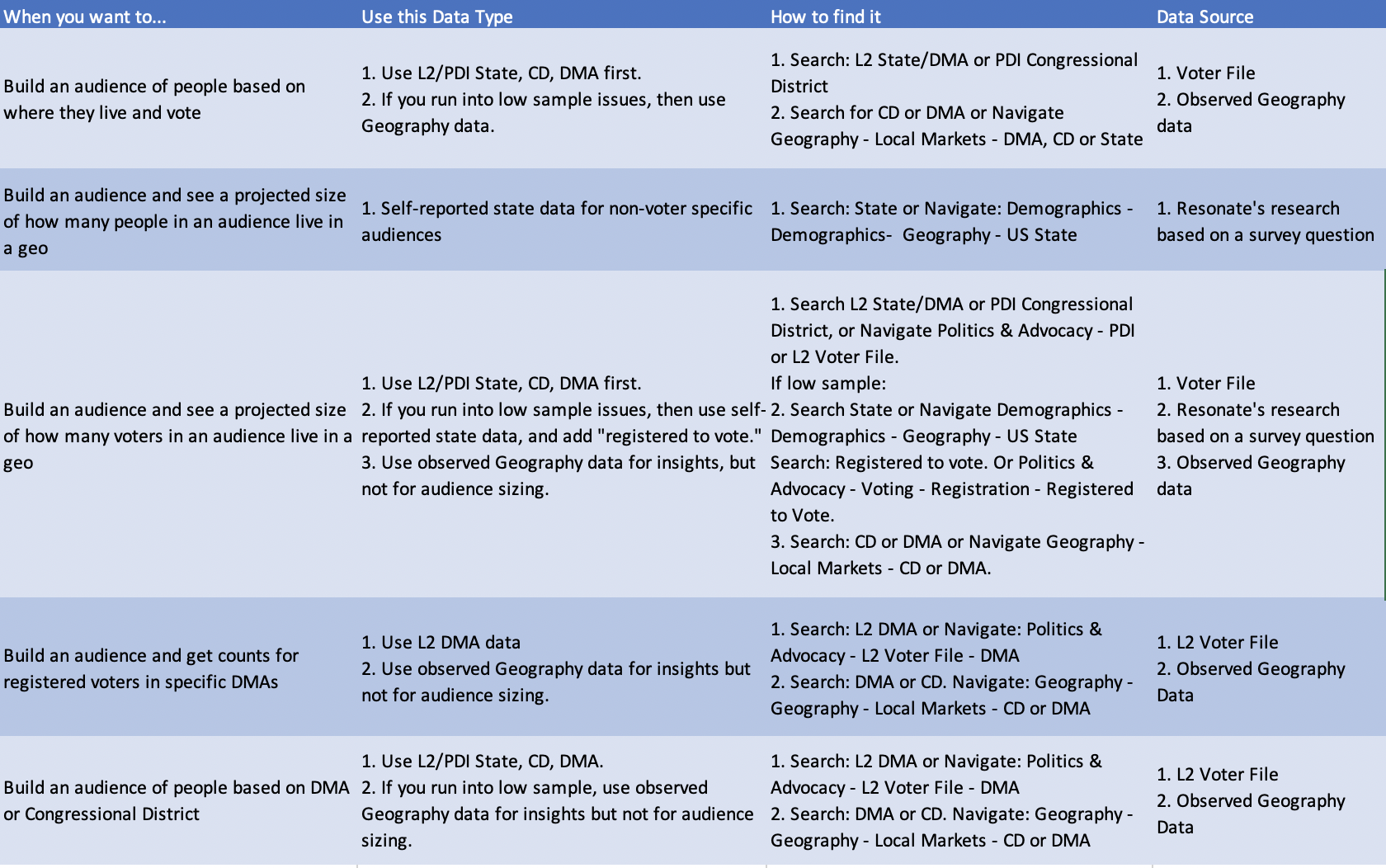
Here's an xls that breaks down further use cases.
Pro Tip: For campaign execution, we recommend using your advertising platform’s geo-targeting capabilities for the most current and precise targeting performance.
Limitations to Three Types of Geography Data
When working with these three data types, keep in mind that they come from different sources, so they may not always "add up" against each other. For example, if you look at several DMAs® in a certain state against that state's attribute, the numbers may look a bit off. Keep in mind that DMAs® can span two or more states, but primarily keep in mind that these three data types come from different sources.
Understanding the Geography Data
Resonate’s Premium Geography Data leverages geographic modeling, refreshed daily, to enable you to:
- Understand where your audiences are at the Congressional District level
- Build or segment audiences by DMA® and Congressional District
- Tailor your messaging, creative, and more by specific geographies
Benefits:
- More granular and accurate geographic insights
- Consistent alignment with political and voter geography
- Weekly updates that maintain data freshness and reliability
*The DMA® information is used pursuant to a license from The Nielsen Company. Any use and/or reproduction of these materials without the express written consent of The Nielsen Company, is strictly prohibited. The DMA® information is valid for the period 2022 - 2026.
Comments
0 comments
Please sign in to leave a comment.